Agreements
At the start of the flooding simulation, a pit is a completely unsaturated, 3-dimensional area that lies completely or partially below the ground surface. The following also applies:
The nodes belonging to a pit are identified by a unique zone number (data type GRUB, numbering > 0).
The boundary condition "free seepage" (data type SICK) must be defined for all FEM mesh nodes of the pit under consideration where an inflow is possible. If there are drainage systems that drain into the pit for dewatering the pit structure, the corresponding nodes with the boundary condition "watercourse stage and leakage" can also be provided with the attribute for zone numbering of the pit (data type GRUB, see above).
At time t=t0 there is no water in the pit (no initial volume).
For a transient calculation, a continuously rising curve is available for the pit under consideration to describe the ratio of the impounded volume (m3 /s) to the impoundment height (m above sea level), known as a stage-volume curve).
Time course of the flooding of a pit
After each time step t = ti, the volume flow that has flowed into the pit from time t = t0 to time t = ti is balanced. The volume is made up of the volume flowing into the pit nodes in the time step under consideration t = ti - ti-1 and the volume accumulated up to the time t = ti-1. If drainage pipes are connected to the pit and labelled according to the definition described above, the volume flowing in from the drainage pipe is added to the volume in the pit.
From the volume V(ti), the resulting water level h(Vi) for the time under consideration is derived with the aid of the stage-volume relationship.
For each node with the boundary condition "free seepage", its vertical position z can now be used to assess whether it is still above the free surface h(Vi). For a node that lies below the free surface, the boundary condition is changed from "free seepage boundary condition" to "fixed potential head" or alternatively to "watercourse with leakage" (receiving water with leakage) with the height h(Vi). The height is updated to h(Vi) for all other nodes with the boundary condition "fixed potential head" or " watercourse with leakage".
This procedure guarantees that the volume removed from the model due to the boundary condition "free seepage" is completely reintroduced by defining fixed potential heads or watercourse nodes and that mass conservation in the model is thus maintained.
Whether the change from "seepage node" to "fixed potential head" or to the attenuated boundary condition "Receiving water with leakage node" should take place is determined during the flow calculation.

If the watercourse boundary condition is selected, a node leakage value (attribute LEKN) must be entered.
Overflow of a pit
If the boundary condition "fixed potential head" applies to all nodes of a pit at a point in time, the pit is considered flooded. In this case, all (potential head) boundary conditions are "deactivated" so that the pit is included in the flow calculation as a fully saturated section of the aquifer.
Lowering the water level of a pit
If the water level in the pit drops, the nodes above the free surface are set back from the "fixed potential head" boundary condition to the "free seepage" boundary condition, in the opposite direction to the water level in the pit.
If the water level is lowered after the pit has been saturated, all pit nodes are reset to the boundary condition "fixed potential head" (below) or "free seepage" (above the free surface) depending on their vertical position at the moment when the water volume no longer fills the pit due to the stage-volume relationship.
Retention water level elevation
If a maximum water level target is defined for a pit, the volume that ensures compliance with the water level target for each time step is taken from the model once this elevation is reached. The calculation of the volume to be removed is carried out with the aid of the stage-volume relationship. The water level target must therefore lie within the value range of the function.
The water level target can be changed over time in the usual way using the transient input file. The data type is described with HMAX, the values are to be related to the zone number of the respective pit.
External water addition from outside the model
If water from outside the model is to be introduced into the pit during the flooding phase, this can be defined as a volume flow. If such a volume has been defined for a time step, it is taken into account when calculating the spreading level using the stage-volume relationship. A mathematically positive rate is regarded as the rate added to the pit, a negative rate as the removal of flood water.
The rates added can be changed over time in the usual way using the transient input file. The data type is described with MENG, values are to be related to the zone number of the respective pit.
Definition of flooding parameters in SPRING
To carry out a flooding simulation using the procedure described above, all FEM mesh nodes describing a pit must first be assigned a unique number in the GRUB data type. This number is then used as the zone number (X) of the pit.
If nodes have been labelled as pits, the extended flooding parameters "Retention water level elevation" and "External additional quantity" can be defined via the menu item Attributes  Extras Flooding parameters. If a set parameter is to be deleted, the entry in the corresponding field must be deleted (field remains empty).

Definition of the stage-volume curve relationship for a transient calculation
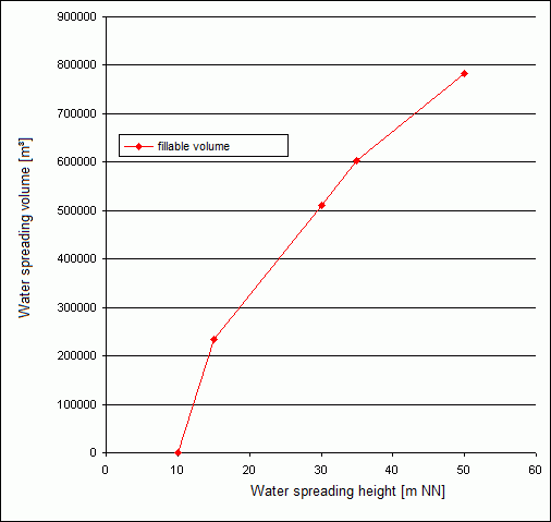
For a transient calculation, a continuous function must be defined for each pit that describes the dependency between the impounded volume and the water level in the pit. This is the stage-volume curve relationship of a pit, also known as the stage-storage curve:
The function should be defined over the entire interval of the water accumulation process, i.e. for all values for volume and height occurring in the simulation.
For the flooding calculation, the stage-volume relationship for each pit must be provided in CSV format (delimiter separated) in a file with the name "grubeX.hv" in the working directory, where X represents the zone number. The file is read automatically by the calculation module. The first column contains the storage water level elevation, the second column contains the storage volume.
10.0,0.0
15.0,234900.0
30.0,511600.0
35.0,602800.0
50.0,783000.0
Results
In addition to the known results (potential heads, free surface, hydrographs, etc.) from the transient flow calculation, a volume hydrograph is generated for each pit during the flooding simulation, which describes the current impoundment volume for each time step and, if the impoundment water level target is defined, a volume hydrograph that describes the volume to be removed. In addition, the volumes for the individual boundary condition types are saved for each time step. The file is created with the name "gruben.csv" in the working directory.
Example of realization in SPRING
Stand: 18.04.2025 | 