This form of interpolation can be used, for example, to interpolate or extrapolate measured level values of a receiving watercourse to the mesh nodes belonging to the receiving watercourse. If the measured values are hydrographs, several points in time can be processed during an interpolation run. (A once-off interpolation of data to a polyline can possibly be carried out more easily in the SPRING interface). This can be used, for example, to generate the transient input file for modelling a flood event in a receiving watercourse.
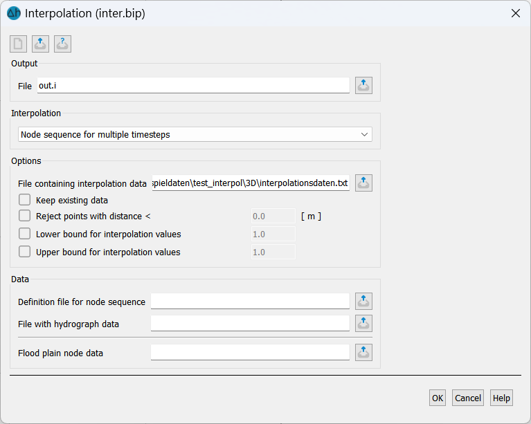
Two files are required for this:
In the first file, the node track (e.g. of the receiving watercourse) is defined as a list of node numbers in the format of the model (*.net) file
In the second file, the measured values (single values or as time-dependent data) are entered in the format of the target hydrographs. The first and last measured values can also be set outside the model area by specifying a distance.
Attention: Data is only interpolated for the time points of the first time step in the measured values file. All data from other points in time are not taken into account during interpolation! Please also note: If the value on a node track is not defined at one of these points in time, the value is not meaningfully supplemented by values defined at the points in time before or after!
To avoid misunderstandings, the following points should be kept in mind:
The time steps of the hydrographs, which are defined in the measured values file at different points of the node train, should be the same at all nodes.
If values are missing at some time-dependent points, these must first be supplemented with meaningful values!
Potential over the depth
For 3D models, the potential head values interpolated from this data at the polygon course nodes of the 1st layer can also be set to the nodes of deeper layers. This is done by activating the Potential via depth checkbox and selecting the deepest layer number.
Consideration of floodplain node data
As part of the interpolation, a transient input file with "floodplain node data" can also be created. The file contains one node number per line. A suitable potential head boundary condition is then calculated for these nodes by simple projection onto the polyline node track. This potential head boundary condition is automatically switched off (output with negative node number) if the calculated potential head is below the surface elevation (GELA) of the node. Consideration of the floodplain is often necessary for large receiving watercourses in order to define the extent to which a flood event affects the surrounding areas of the receiving watercourse, e.g. in order to write out flooding areas.
This procedure is best explained using the following example.
 Realization in SPRING
Stand: 30.01.2025 | 