SPRING has two modules for interpolating data:
SPRING calculation module Interpol (Calculation
 Interpolation...)
SPRING attribute menu (Attributes
Assign By interpolation...)
In principle, a distinction is made between two different types of data interpolation:
Areal interpolation of node or element-related data: Various interpolation algorithms are available here to interpolate values (zi) at grid points (xi, yi) over an area to all nodes or elements. Additional information can be taken into account during interpolation. Special functionalities have been developed for the interpolation of groundwater contour maps in particular to incorporate previously recorded model information into the interpolation.
Linear interpolation of interpolation point data (also transient data / hydrographs) to all nodes of a defined linear node selection.
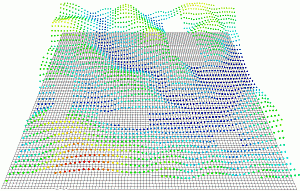
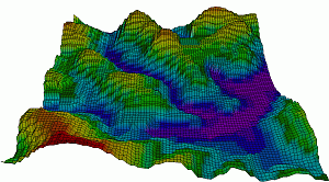
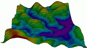
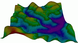
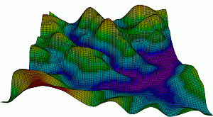
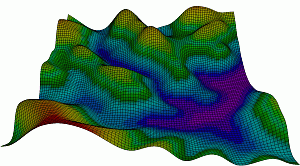
The following figure compares the different interpolation algorithms.
|
Element mesh with interpolation points |
Nearest Neighbour method |
|
Distance weighting (500+2) |
Area interpolation (1 pass) |
|
Gauß interpolation |
Kriging (Fitting polynom) |
Interpolation with the nearest neighbour algorithm is only available in the SPRING attribute menu (Attributes Assign By interpolation...), while the interpolation methods distance weighting, area interpolation and Gaussian interpolation can be selected both in the attribute menu and in the calculation menu (Calculation Interpolation...). However, the Kriging method is only available in the Interpolation calculation module.
In general, the interpolation of node and element data (surface data) via the SPRING attributes menu should be favoured for the following reasons.
The implementation of area and Gaussian interpolation utilises data structures and parallel processing. As a result, the algorithm is very fast, memory-efficient and can process enormous amounts of data
For 3D models, data can also be interpolated to the lower layers
Input Parameters of the Calculation Modul "Interpol"
Stand: 30.01.2025 | 