As already described, when creating groundwater contour maps, it makes sense to include boundary conditions such as fixed potential heads, boundary inflows, receiving watercourse conditions (reference potential heads and leakage connection) or open water areas (equal potential heads) in the interpolation in addition to the values measured at the groundwater measuring points. Especially for automatic calibration with the gradient method, a groundwater contour map that takes the hydrogeological conditions into account is indispensable.
For the interpolation of groundwater contour maps, creating a copy of the current mesh (*.net) file is recommended, as some attributes must be assigned special values that are only useful for the interpolation of groundwater contours.
A zip archive with sample data is available for download on our homepage under the Download and Support  Documentation section. The Tut_Intpol_GwGl directory contains an example mesh and a file with measured groundwater levels (gwmesspkte_int_gwgl.txt), which should be used for the interpolation of a groundwater contour map.
The following processing steps must be carried out in order to create an interpolated groundwater contour map.
To take into account a water body with a leakage connection, a leakage factor LEKN between 0.0 (= no groundwater contact) and 1.0 (= complete groundwater contact = fixed potential) must be specified at the corresponding model node. Existing LERA and LEEL attributes should be deleted. Only then will this body of water be taken into account in the interpolation.
In the example, the receiving water nodes 204 to 215 are assigned the LEKN value = 0.9 via the Attributes Assign Direct... menu item. For the upper reaches (nodes 216-221), it is assumed that there is no groundwater connection due to the higher lying stream bed. LEKN = 0.0 is assigned in this area (see figure below).
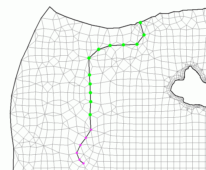
Assigned LEKN attributes (green = 0.9, pink = 0.0)
If the no-flow boundaries are to be explicitly taken into account, the attribute KNOT = 0.0 must be set for the interpolation at these nodes.
The KNOT = 0.0 attribute is therefore assigned to the edge nodes on the western and southern edges.
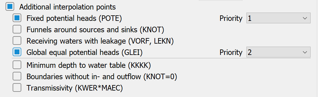
After saving the file and performing a model check, interpolation can commence by opening the Interpolation... window. Select the interpolation type "Groundwater contour map" and activate the "Additional interpolation points" checkbox. Now you can activate the:
"Receiving waters with leakage" checkbox, and the
"Boundaries without in- and outflow" checkbox.
The numbers 1-4 after the selected attributes define the priority with which the attributes are to be taken into account during interpolation:
After selecting the "File containing interpolation data", the calculation can be started. The calculated groundwater elevations can be displayed in SPRING via Attributes Import model data/result data... to the desired identifier (e.g. EICH).
The following figure compares the isolines of an interpolation without (blue, i.e. only the measured values of the gwmesspkte_int_gwgl.txt file were taken into account) and an instance with consideration of additional interpolation points (red).
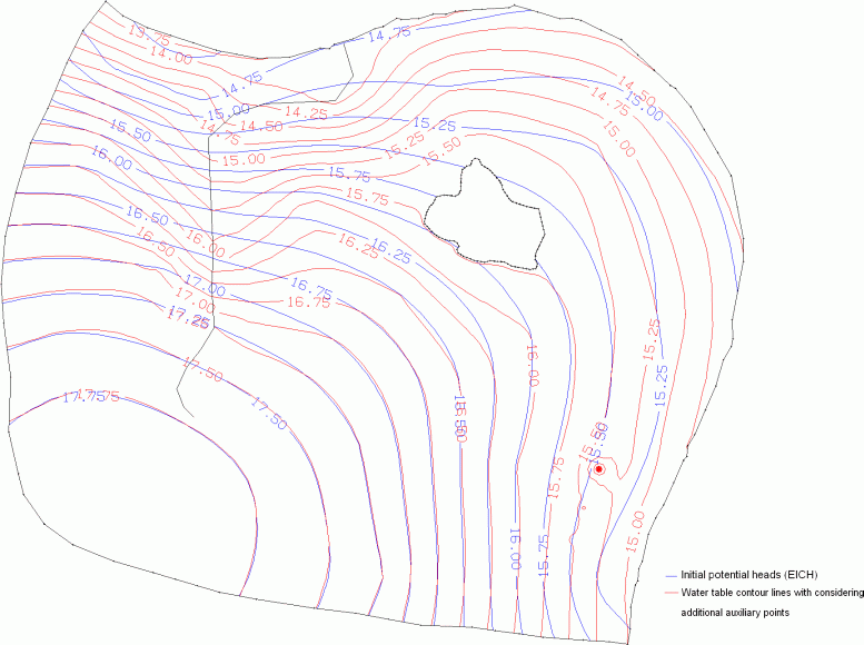
Bild: Comparison of the isolines after interpolation without (blue) and with (red) consideration of additional interpolation points
The following image shows a section in the area of the watercourse, in which it is particularly clear that the inclusion of the stage height (water level) of the watercourse in the equalisation plan calculation makes a groundwater connection of the watercourse visible in the contour line plan!
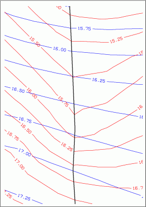
Bild: Visible groundwater connection of the watercourse by taking into account the receiving water/leakage relationship in the interpolation
Attention: For further flow calculations, it is recommended to delete the attributes KNOT = 0.0 and to set nodes with LEKN values to suitable leakage values (LERA), as the values between 0 and 1 are usually ONLY useful for the interpolation process!
The new interpolation points calculated during the interpolation are saved in the file "stuetzTMP.txt". If this data is merged with the input file "gwmesspkte_int_gwgl.txt", a file with all the interpolation points required for the groundwater contour map is created.
In addition to the influences shown above, it is sometimes advisable to take other parameters into account:
The KKKK attribute can be used to enforce compliance with minimum groundwater depths in certain areas. For this purpose, the desired distance between the surface and groundwater level (in metres) must be defined via the attribute KKKK. If the interpolation in these areas results in a smaller distance than specified, a correction is made to the value for KKKK.
In order to take into account the influence of the hydraulic conductivity coefficients (KWER) and the thickness (MAEC) of the saturated zone, a transmissivity-weighted interpolation between the groundwater measuring points can be prescribed, provided that the element attributes KWER and MAEC are defined for the entire area. On an imaginary line between two neighbouring monitoring wells, the hydraulic gradient is weighted using the transmissivity of the mesh elements intersected by the line..
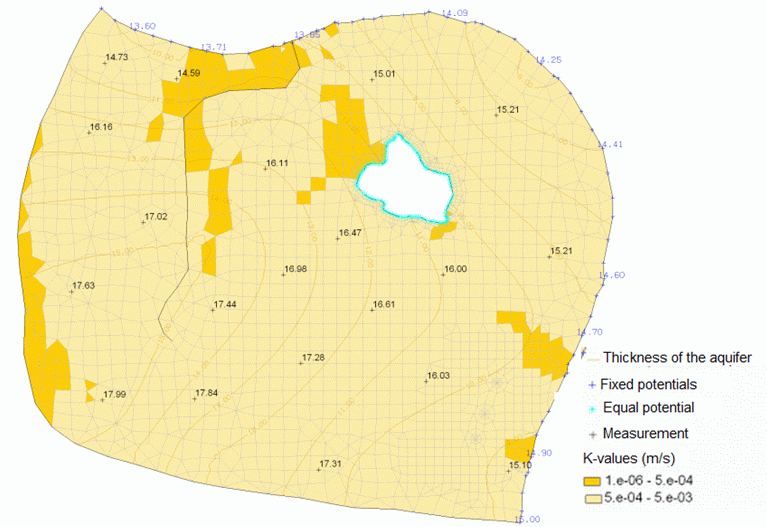
Initial situation with the model starting values
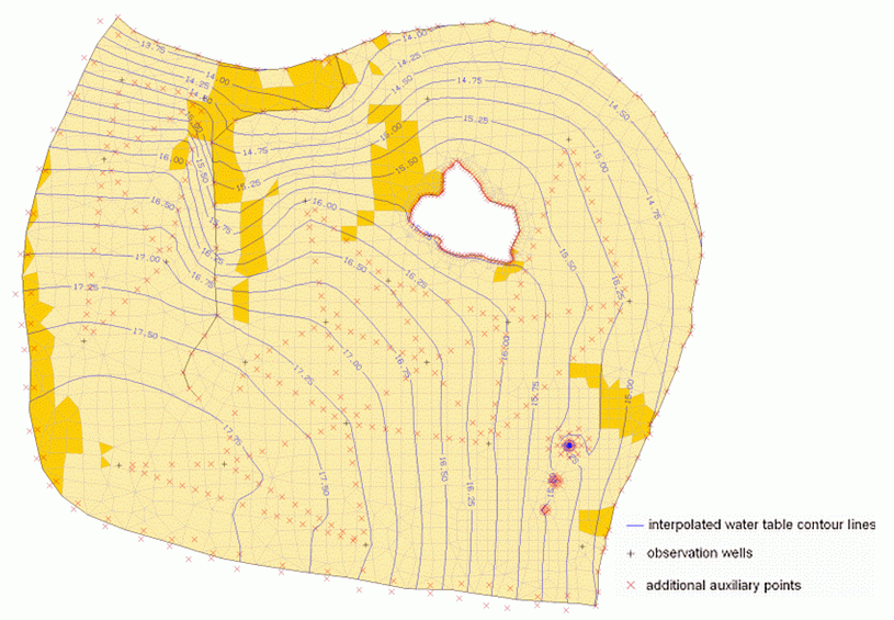
Contour map taking into account various hydrogeological parameters
It is noticeable that a transmissivity-related interpolation has not taken place between all measuring points. This is due to the fact that interpolation only takes place between the measuring points between which there is a variation in transmissivity of more than 10 % and between which there are more than 3 finite elements.
The inclusion of transmissivities in the interpolation algorithm requires sufficiently precise knowledge of the hydraulic conductivity distribution and the saturated thickness of the system prior to calibration. As this programme functionality can currently only be applied simultaneously between all measuring points, it should only be used with a sufficient number of groundwater measuring points and/or a correspondingly coarse mesh discretisation.
Interpolation along a node track taking floodplains into consideratio
Stand: 30.01.2025 | 