The question of the catchment areas of receiving watercourses or wells often arises, e.g. when assessing and defining drinking water protection zones or the area of influence of an abstraction well.
With the FLIC programme (Konrad-Zuse-Zentrum für Informationstechnik Berlin), it is possible to display the calculated velocities as "streaks" after a flow calculation. This visualisation technique provides a much better idea of the flow paths than the usual flow arrows of the velocities, especially for 3D models, where by definition no streamline calculation is possible.
In the modified example model, there are now two well areas that can be clearly distinguished from each other using the loop representation.
The procedure for the schlieren display is as follows:
Once the flow calculation has been successfully completed, the calculation for the display is performed using the File  Export Schlieren plot... menu item. The following input window then appears:

The output files are preset with the name "out", the name can be changed by the user. The six output extensions .ascii, .sca, .mar, .scr, .jpg and jwg are attached.
The streaks are displayed in ".jpg" format with the ".jgw" world file required for georeferencing. The colour of the streaks can be changed by selecting a data type (model or result data). In the example, the potential heads were selected as the colour source.
You get the following picture:
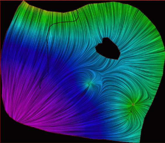
Schlieren plot of the potential heads
The catchment areas of the well (or wellfield) can be digitised as an area or line structure along the course of the Schlieren using the structure menu in SPRING (model file mode), for example. The jpg file can also be opened in plot mode, the line or area objects can be drawn and saved as a plx file.

To compare the determined catchment areas with FLIC with the calculated trajectories and streamlines, one of the plx files (e.g. the trajectory line representation) is opened and the plx file of the streamline representation and the Schlieren representation are overlaid (File Import Overlay file... Select the corresponding file type).
You can clearly see that the course of the streaks corresponds to that of the path and streamlines. The remaining files can be used in other geoinformation systems (e.g. ARC INFO).
After deleting the hatching display, the catchment areas can be overlaid with the topographical map to establish the local reference. To do this, you may first need to change the visualisation of the area structures from a border to a filled area.
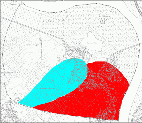
Catchment areas of the wells
Stand: 23.03.2025 | 