The lower surface of the aquifer present in the model file forms the lowest node layer. The ground surface (GELA) or - if none is available - an entered groundwater level (EICH) or - if neither is available - the model surfaces interpolated to nodes (OBER) define the uppermost nodal layer. The nodal layers in between are generated by specifying the division ratio of the desired layers.
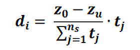
This approach is suitable for aquifers without distinct geological stratification, where the spatial flow of the groundwater is caused by external factors (e.g. partially penetrating well or seepage beneath a structure or river).
 Realization in SPRING
Stand: 22.01.2025 | 