2DMO
This command stands for a horizontal plot in a horizontal model or for a 2D plot in a vertical model. No further input is required.
The command is only required in combination with another scaling (batch command SKAL ) command, otherwise it is not necessary. This command is automatically inserted in the batch file when editing with the user interface if the corresponding plot type and model type are selected.
HORI
The command is used to enter the layer number for a horizontal section in a 3D or 2D model with a 3D sub-area.
Input:
1. Line: Layer number (integer number) greater than or equal to 0
The layer numbers 0 and 1 provide plots of the node and element data for the 1st layer. For a 2D model with a 3D sub-area, only the 3D sub-area is plotted for a layer number > 0. If the layer number = 0, the data of the first layer is displayed for the entire 2D/3D area. (Note: There is one more node layer than element layers!)
This command is automatically inserted in the batch file when editing with the user interface if the corresponding plot type and model type are selected and takes over the input from the user interface.
VERT
The command describes a vertical section in the horizontal, 2D model with 3D sub-area or 3D model and requires the entry of node numbers for the section line. This command is automatically inserted in the batch file when editing with the user interface if the corresponding plot type and model type are selected and takes over the input from the user interface.
Input (separated by spaces or tabs):
1st Line: Number of section nodes (at least 2!)
From 2nd line:
Number > 0: Node numbers (max. 10 per line)
Number < 0: Number of sequence lines with (x, y) coordinates and layer number if applicable
For a 2D model with a 3D sub-area, only sections through the 3D area are permitted. When cutting through nodes that are not connected by element edges, a 'straight' section is drawn between these nodes across the elements. Some plots are then no longer possible (e.g. values in elements).
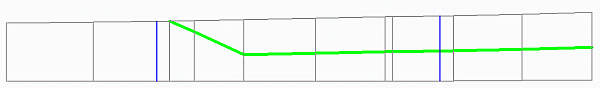
The vertical section through a horizontal model is only possible if the lower edge and surface (e.g. from ground level or calibration potential heads or the top edge) of the modelled aquifer are defined. If the aquifer is delimited at the top by a terrain height and thicknesses are also defined for an impermeable layer (UNDU attribute), this vertical subdivision of the aquifer is considered in the mesh plot ((batch command NETZ).
The following figure shows the vertical section of a horizontal model with an impermeable layer, the lower edge of which is shown in the mesh plot (green).
 Plot parameters
Stand: 02.06.2025 | 