Attributes:
VORF [meters above reference datum] (node-wise)
ABRI [m] (node-wise)
Reference water levels or stage for watercourses (VORF)
The reference water level for watercourses is required to calculate the potential head difference (hVORF – hGWL) and the resulting corresponding leakage rate (via a linear relationship).
An 'F' in column 15 means that the reference water level of the watercourse is not influenced by subsidence calculations . In a simulation with transient subsidence, however, the reference water level for watercourses is always influenced by the transient subsidence. The symbol 'F' is thus irrelevant in this case). The VORF boundary conditions can also be defined as a transient boundary condition (transient VORF data).
The reference water level for watercourses data type is only active when defined in conjunction with a leakage coefficient.
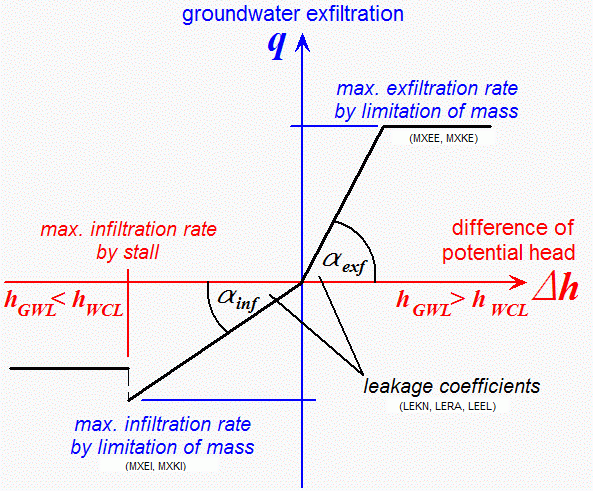
Tear-off height for watercourses (ABRI):
To take limited infiltration conditions into account at nodes which receives infiltration from a watercourse, a value can be defined at which the maximum possible infiltration volume is reached and infiltration ceases (i.e. the infiltration rate becomes zero, also known as reaching the infiltration capacity). This value is obtained when the groundwater level (hGWL) falls below the difference between the base level (hBottom) and the ABRI value. In this case, the potential head difference of hVORF - hBottom is determined to calculate the resulting leakage rate. In this context, hBottom corresponds to the ground level.
ABRI boundary conditions can be defined transiently (transient ABRI data). The following figure illustrates the relationship between reference water level and tear-off height for watercourses:
Relationship between the water level elevation and the tear-off height
Stand: 06.05.2025 | 