To access the relevant menu, navigate to Attributes Compute Groundwater recharge RUBINFLUX ... the following submenu appears:
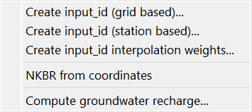
The first three menu items enable dialogue-based creation of climate time series (input_idNummer.csv) from a wide variety of weather and climate data such as HYRAS grid data or DWD station data.
Each of these three menu items is described in a separate chapter due to their complexity.
NKBR from coordinates
This menu item enables the determination of the attribute NKBR (latitude ) directly using the georeferenced node coordinates. The data type is automatically assigned to the elements.
Compute groundwater recharge...Basic settings
If all required input data (required model data and climate time series) are available, this function calculates the transient recharge rates. These rates are calculated either for a transient input file or as mean recharge for the model file. Alternatively, an "on-the-fly" calculation of the daily recharge rates can be carried out during transient flow calculation using the same input parameters. More details can be found in the chapter "Unsteady flow calculation - RUBINFLUX".
Upon selection , the "Basic settings" input window appears:
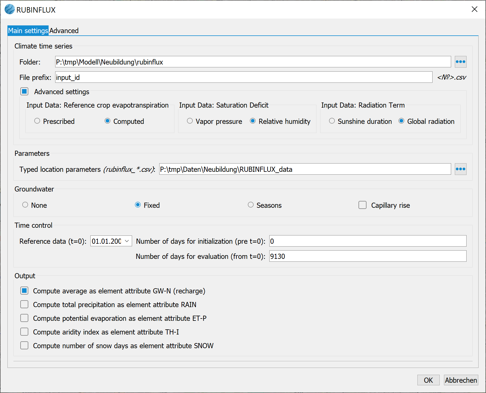
Climate time series - Files
Here, the local folder where the climate time series files are stored is specified. The file prefix must be identical for all climate files. Example:
Prefix = input_id, then the file names should follow the pattern: input_id501.csv (for elements with NKID=501), input_id50.csv (for elements with NKID=50) etc. All climate time series must begin with the same (start) date. Under normal circumstances, the input_id settings are automatically recognized based on the column names. Therefore, activating the "Advanced Settings" button is only necessary if the column names are ambiguous.
Typified location parameters
SPRING provides default location parameters files for various attributes, including, soil type (_soil), vegetation period (_season), leaf area index (_lai), SCS parameters (_cn2), simulation depth (_simdepth) and crop coefficients (_kc_season, _kc_month). These files are located in the directory "C:\Users\Public\Documents\SPRING\Konfig" (Windows 10).
However, project-specific or user-specific versions of these files can be stored in the corresponding project folder/directory. The corresponding path can be selected here.
File format requirements for *.csv files: Column separator = semicolon, Decimal separator = point or comma.
During transient recharge calculation, an "on-the-fly" linkage of the underlying tables is carried out using the mode's element data.
Groundwater
By activating the buttons fixed or seasons, it can be selected which groundwater level should be considered in the recharge calculation. In this case, the simulation depth specified in the location parameters is overridden when the predetermined value is reached. When groundwater emerges at the ground surface (ground level distance >= 0), the recharge portion goes into direct runoff. When the 'fixed' button is selected, the EICH potentials from the model file are used for the calculation. Selecting the ‘seasons' button uses the minimum and maximum ground level distances that occur for the calculation. The minimum ground level distance corresponds to the ground level distance at high groundwater levels (attribute FHGW). The maximum ground level distance corresponds to the ground level distance at low groundwater levels (attribute FNGW). The attributes must first be determined by the user from the corresponding time series or groundwater contour plans and assigned to the model nodes.
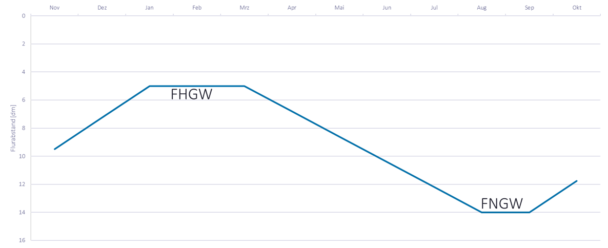
Example of a constructed groundwater annual cycle
To account the capillary rise, the activation of fixed or seasons flow is mandatory.
Time control
Firstly, the reference (starting) date for the transient file is defined.
The "Number of days for initialisation" input can be used to specify the the number of days to be included in calculations before the reference date.
The "Number of days for evaluation"defines the period over which the data iscalculated or exported from the reference date
In the advanced settings, the user must specify the type of the averaging method for transient groundwater recharge. This determines whether calculations are performed daily (averaging = 1) or, for example, only for every 10th day (averaging = 10, represents the average value over 10 days).
Output options
By activating the first checkbox, the element mean values of the groundwater recharge (attribute GW-N) and the rapid runoff components , as determined by the specified time control , are calculated. The rapid runoff component influenced by the soil-dependent parameters , ASCS , is assigned to the attribute NKAG while the runoff component, influenced by sealing ,AVERS , is assigned to the attribute NKAV.
The remaining checkboxes allow for the optional assignment of other result data from the regeneration calculation to the elements.
Compute groundwater recharge...Advanced
The following input window appear:
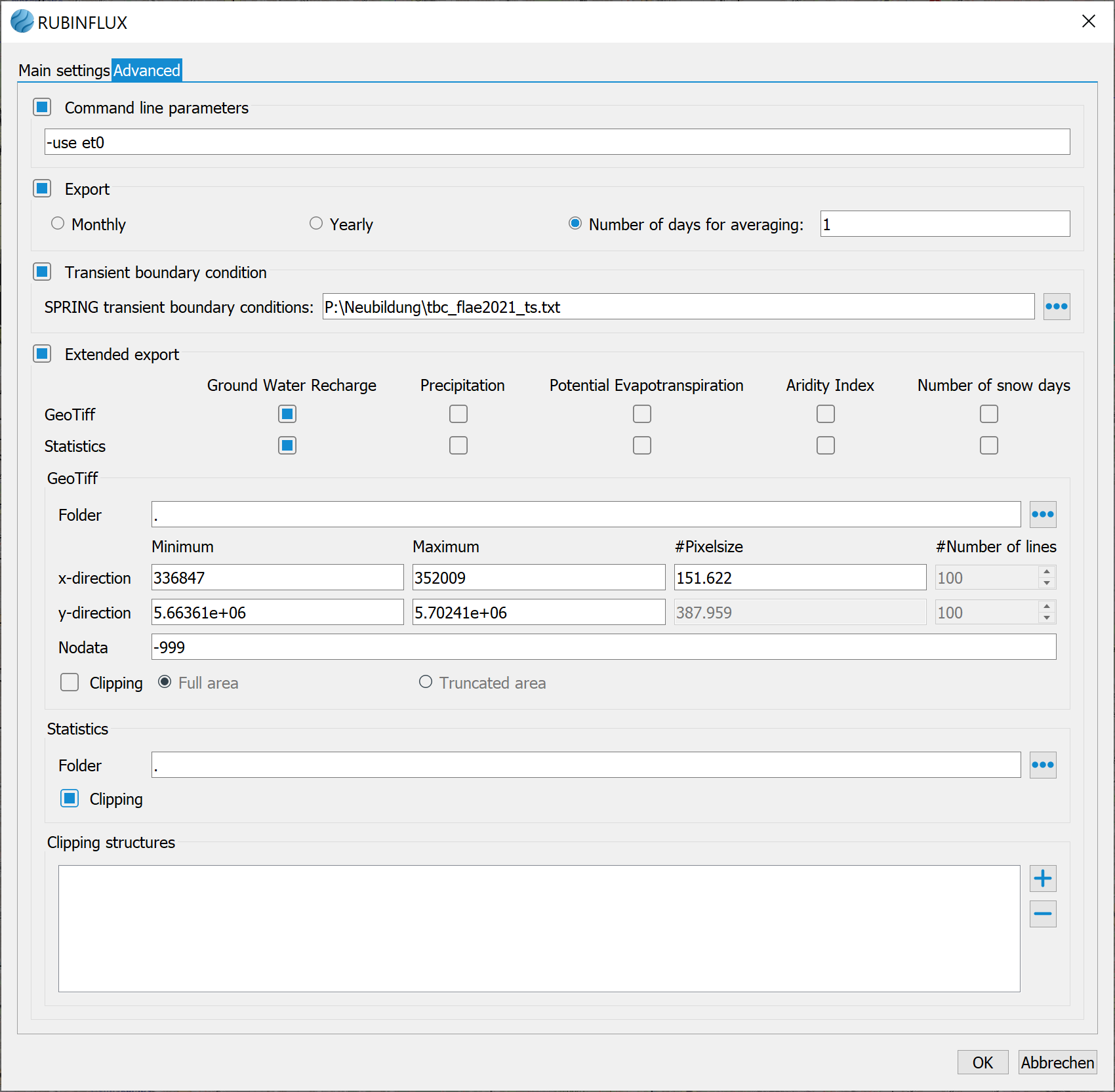
Command line parameters
Programme control via the command line parameters is currently intended fordevelopment purposes only, and is restricted to developers.
Export
Here the user must define the averaging method, specifying whether the transient groundwater recharge is calculated daily (averaging = 1) or, for example, every 10 day (averaging = 10, corresponds to the average value over 10 days) or monthly or annually.
Transient boundary condition
If a transient input file is required for the groundwater recharge, this is specified here. The calculated groundwater recharge is then saved as a transient boundary condition based on the selected averaging factor, e.g. daily or only for every 10 day.
Extended export
The calculated data can be exported as GeoTiff files , with the option to define a specific section for export.
Statistical output is also available.
By specifying a clipping area (importing existing (area/polygon) structures), the data can also be exported in sections. Additionally, users can determine whetherelements partially intersecting the"clipped"e structure should be considered in full or only proportionally.
Generate input_ids (grid-based)
Stand: 25.10.2025 | 