Structural data, including points, lines and polygons, can contain additional data details (attributes, description of data types) beyond their inherent geometric information. A distinction is made between:
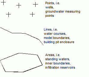
Point structures (zero-dimensional geometry)
Line structures (one-dimensional geometry)
Surface structures (two-dimensional geometry)
Structure types
Using these structure types and assigning all the corresponding information allows all the data required for a groundwater model to be included, for example:
Point structures:
Coordinates of abstraction or injection wells
Coordinates of groundwater observation points, including groundwater elevations
Line structures
Watercourse systems, including the elevation of water in the watercourse and leakage coefficients or ex-/Infiltration volumes
Construction pit enclosure (sheet piling or sealing walls)
Trenches, tunnels, navigation/shipping channels
Sewerage and drainage systems
Surface structures
Areas of varying groundwater recharge
Areas with different soil characteristics or hydraulic parameters
Surface bodies of water (lakes or ponds) with and without overflow
Seepage basins with infiltration volume
The structures ( INCLUDEPICTURE \d ".\\grafik\\structures_selected.png" \* MERGEFORMATINET INCLUDEPICTURE \d "C:\\Projekte\\SPRING-Hilfe_Englisch\\Getting_started\\grafik\\structures_selected.png" \* MERGEFORMATINET INCLUDEPICTURE \d "C:\\Projekte\\SPRING-Hilfe_Englisch\\Getting_started\\grafik\\structures_selected.png" \* MERGEFORMATINET INCLUDEPICTURE \d "C:\\Projekte\\SPRING-Hilfe_Englisch\\Getting_started\\grafik\\structures_selected.png" \* MERGEFORMATINET INCLUDEPICTURE \d "C:\\Projekte\\SPRING-Hilfe_Englisch\\Getting_started\\grafik\\structures_selected.png" \* MERGEFORMATINET INCLUDEPICTURE \d "C:\\Projekte\\SPRING-Hilfe_Englisch\\Getting_started\\grafik\\structures_selected.png" \* MERGEFORMATINET INCLUDEPICTURE \d "C:\\Projekte\\SPRING-Hilfe_Englisch\\Getting_started\\grafik\\structures_selected.png" \* MERGEFORMATINET INCLUDEPICTURE \d "C:\\Projekte\\SPRING-Hilfe_Englisch\\Getting_started\\grafik\\structures_selected.png" \* MERGEFORMATINET INCLUDEPICTURE \d "C:\\Projekte\\SPRING-Hilfe_Englisch\\Getting_started\\grafik\\structures_selected.png" \* MERGEFORMATINET INCLUDEPICTURE \d "C:\\Projekte\\SPRING-Hilfe_Englisch\\Getting_started\\grafik\\structures_selected.png" \* MERGEFORMATINET ) can be created directly on the screen (e.g. based on a topographical map) or imported from existing ASCII files (e.g. *.txt, *.csv, *.shp or *.dxf). The structure menu also offers extensive editing tools.
 Contours
Stand: 29.10.2025 | 