This menu item is about the treatment of watercourse systems. The following items are available:
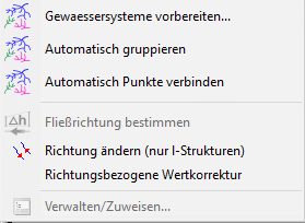

River system preparation...
The following input window appears:
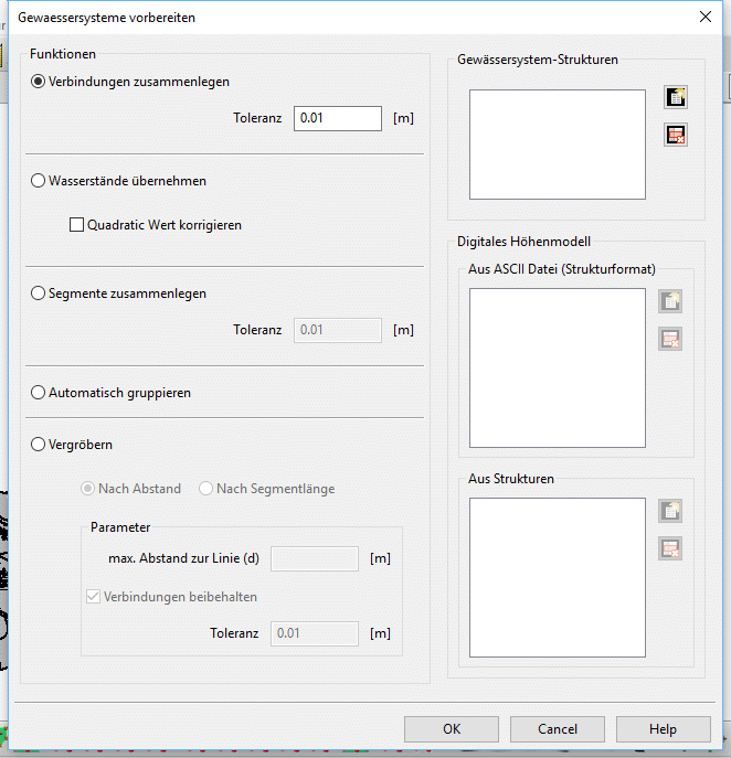

Joint connection tool
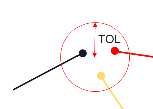
The joint connection tool is used to automatically detect and connect structure joints that lie within a user-specified radius of each other throughout the model. This is especially important with regard to further manipulations for which the river system must first be grouped, since the grouping algorithm generally construes as disparate points and therefore rivers whose coordinates do not precisely coincide. The algorithm simply searches for points within the specified radius and subsequently attempts to join them in case they belong to separate structures—points from the same structure will not be joined, which would otherwise lead to an overlap. All structures will retain their initial values as no calculation is involved the process. The number of modified points is shown when the procedure ends.

Water level calculation
This feature can automatically calculate and correct water levels and determine flow directions of river systems in the model. The algorithm employs a robust combination of geometrical and geological analyses for this purpose. Needless to say, the outcome of this tool heavily relies on the correctness and accuracy of the provided input data.
In general, the following steps are required to utilize this tool. Firstly, the structures corresponding to the river system must be selected. These structures are necessarily line structures, and any other type would internally be rejected. Nonetheless, care should be taken regarding the correctness of the selected structures since any line structure would indiscriminately be acceptable as the algorithm has virtually no way of determining whether a given line structure is in fact part of the river system or not. River structures may be selected from a list on the top left side of the dialog shown in Figure 1. Next, the digital terrain model data should be selected, which could be in the form of a structure in the model or an ASCII file. In case the digital terrain model is selected as a structure, it must necessarily contain the GELA attribute since this attribute is essential for interpolation and subsequently the statistical analysis in the algorithm. Multiple structures and/or ASCII files may be selected simultaneously, in which case they will be treated as a single aggregate point cloud.
After the successful selection of the river system structures and the digital terrain model data, all the necessary data for this tool is available. The algorithm determines water levels through all river systems in the model using a combination of Gaussian interpolation and a specialized correction algorithm. Flow directions are detected by a robust algorithm that employs a combination of geological and statistical analysis of the river system. Subsequently, the obtained values are corrected based on a series of criteria that ensure both continuity and compatibility through each river system. Moreover, flow directions are visualized with arrowheads, and the results of the analysis are stored in the VORF attribute of each individual structure—note that the existing data in this attribute will be overwritten.
To add a few caveats worthy of mentioning, it is reiterated that one should particularly be scrupulous to ensure the soundness of the selected input data, namely, continuity of the structures at joints where a single river is represented by multiple structures must be checked since the algorithm does not automatically check for discontinuities—the joint connection tool may be used prior to this tool for this purpose. Additionally, the accuracy and appropriateness of the digital terrain model should be checked for the river systems since water levels are inescapably dependent on the interpolation results, and while flow directions are computed using a combination of methods that try to deduce the most accurate results from the provided information, an excessively coarse digital terrain data might lead to insufficient values for individual rivers. Furthermore, the correction algorithm works at its acme when river structures are as long as possible, i.e., there are abundant data points for the algorithm to avail itself of. Therefore, it is recommended that the structures be prepared in such way prior to water level calculation, ideally with each river corresponding to a single or only a few structures. The merging tool might be of help in cases where manual manipulation of the structures is strenuous. This tool runs in parallel to boost efficiency on several layers whenever possible.

Merging tool
The merging tool will simply look throughout the river system and detect river segments that may safely be combined without the potential risk of changing the geometrical interpretation of the system. This tool is helpful in a number of scenarios, e.g., when the river system is imported from shape files, leading to individual rivers being represented by numerous small segments that could easily accumulate to thousands of structures in relatively large models. Handling fewer structures, of course, is often more desirable and at the very least facilitates the modeling process, not to mention that it is sometimes necessary to work with a continuous structure.
It is important to note that the algorithm does not attempt to make speculations regarding the general path of rivers, and the merging process stops when there are ambiguities. For example, a Y-shaped group of rivers would be merged up to the three main branches, but one path is not further preferred over the other. On the other hand, structures are not split under any circumstance. These rules are to ensure generality of the algorithm for all potential geometries. Another important note is that as there are no attribute calculations involved in this tool, all structures will retain their initial values. Furthermore, the same rules from the main structure menu item for manually merging two structures apply here. This tool runs in parallel whenever possible..

Automatic grouping tool
The automatic grouping tool is used to put together connected assortments of structures in individual groups. This procedure is necessary prior to some calculations. This tool does not discriminate the selected structures based on their attributes, i.e., all selected structures are valid as long as they are line structures; hence, when used for river systems, care should be taken to include only structures in the model that are part of the river system.

Coarsening tool

Coarsening is typically useful where the handling of the model and calculations are weighted down by existing structures carrying excessive or redundant points that may be represented by a coarser structure with fewer points without losing substantial information. The coarsening tool allows users to coarsen structures based on two different criteria.

The first method is based on the perpendicular distance between each point within the structure and the line formed by connecting the two points immediately surrounding it. The maximum distance may be specified using the corresponding field in the dialog. Points with a shorter distance than the specified value will be detected and removed by the algorithm.
The second method is based on the length of each segment in the structure. Specifically, the algorithm removes the minimum number of points required for the resultant structure to consist of segments whose lengths are greater than or equal to the user-specified value.


In addition, it is possible using the joint detection option to exclude points with connections from the coarsening process. In other words, when this option is enabled, points within a structure that are connected to other structure points will remain in the coarsened structure regardless of the location in the initial structure and the selected coarsening parameters. This option ensures, for example, that the coarsened structures within a given river system will retain their initial connections, which prevents loss of geometrical information while allowing the system to be represented using fewer nodes. One important point here is that a connection is defined when a structure point lies within a user-specified value of another structure point. The tolerance defines the radius within which a point is considered as connected to another point. It translates into precise connections if the tolerance is small enough, while a larger tolerance will lead to the exclusion of points that are only close enough to other structure points. All existing line structures in the model—and only line structures—are taken into account for this option.

Finally, it is important to note here that structure points that satisfy the mentioned criteria along with all their attributes are removed during this procedure. Therefore, a proper choice of the coarsening method and parameters is crucial to obtaining appropriate results..

Group automatically 
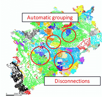
The automatic grouping tool is used to put together connected assortments of structures in individual groups (line structures with attribute VORF). The related water course systems are coloured identically.

Join connection automatically...
Es erscheint ein weiteres Eingabefenster:
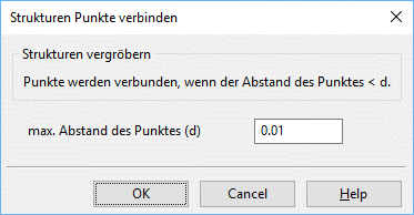
The joint connection tool is used to automatically detect and connect structure joints that lie within a user-specified radius of each other throughout the model.

Identify flow direction 
This menu item determines the direction of flow of watercourse systems by their water level. The flow direction is marked by arrows.

Change direction (l-structures only) 
By this menu item the direction of selected watercourse systems is changed.

Directional correction of values
By selecting this menu item, structure values, which heights (e.g. water course levels) do not descend in the flow direction, are sorted out.

Manage/Assign…
After automatically grouping the structure groups can be managed. An input window appears to Show/Disband/Assign structure groups:
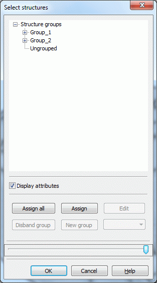
The dialogue shows:

the to individual water systems combined structure groups and

the structures not combined to water systems.
Not to the water systems belong point or area structures and linear structures to which the attribute VORF is not assigned. If there are structural groups, these can be assigned either "all" or "individually".
With Disband group individual groups can be deleted. Via New group new structure groups can be created.
After assigning them all related water systems can be displayed via View  Show attributes
  Watercourse systems.
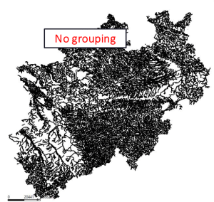
The graphics show a comparison of water systems that are not prepared and grouped (left) and that are geometrically prepared and grouped (right).
|
|
|
|
Without preparing and grouping |
With preparing and grouping |
The same colors show water systems, which form a unit through their connection and their bottom or flow gradient.

