Call via: SPRING  Calculation Model calibration (gradient method)…
When assembling the input for a groundwater model, the different types of data (i.e. the permeability or the potential heads) are usually determined independently of each other. The parameters and boundary conditions are either known or estimated. In running the model, these different datasets are linked together through the mass balance which must always be satisfied. In most cases, the calculated groundwater levels will then differ from the measured ones, even after any obvious errors (wrong exfiltration rates or boundary conditions) are eliminated. The remaining error is generally due to data uncertainty, and usually the permeability K is the most uncertain parameter.
If the user provides an initial permeability, the permeability of the elements can be iteratively calibrated with the help of the model calibration with the gradient method. The iteration is done until the differences between calculated and measured potential heads reach a minimum. The following model types can be calibrated:

2D horizontal models
2D/3D models
3D models
The calibration is done for an assumed steady state. Hence, it is necessary to use initial conditions that are as close to a steady state as possible. The gradients of this initial state must comply to the overall flow direction. Otherwise, the resulting permeabilities might lack the scientific background. Please be careful with sources, sinks and water sheds.
The desired condition is defined by the dataset of initial potential heads (Attribute EICH) at each node. These can be interpolated from field measurements. Alternatively, the necessary values can be gained from scanning equipotential lines from hand-made maps. The results of an interpolation should be considered as such rather than as "real" field data, as small errors within the input data sets may lead to large errors in the resulting calibrated permeabilities. Please consider the suggestions in the preceding paragraph!
The chapter: ”Interpolation of groundwater contour maps” describes how all the data which affects the groundwater is taken into account.
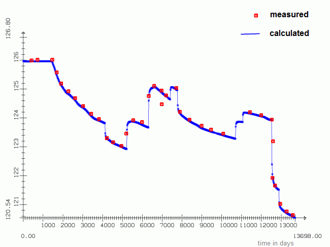
Example of a transient calibrated hydrograph
In a following chapter the calibration with the help of the inverse modelling is described.
Iterative calibration of the horizontal K-values