The following data must be available for all elements in the model file.

Surface sealing (attribute VERS, optional): The degree of sealing is specified in the unit [%]. It is necessary to calculate the sealing dependent "rapid" runoff.


Slope (attribute GGRD): For elements to which the attribute GGRD is not assigned the rapid runoff component ASCS is not disconnected from the precipitation.

Layer height (attribute NKLH): NKLH is required for the calculation of the reference grass evaporation and refers to the sea level (e.g. m NN, m NHN, mamsl).

Latitude (attribute NKBR): NKBR is required for the calculation of the reference grass evaporation. The unit is [°].

Land use (attribute NKFN) [nr.]: The specification of the land use is made via the ID assignment according to the definitions in the files for the global location parameters (see below). Unless own definitions are made the IDs correspond to the following table:
|
ID |
Land use |
|
1 |
Grass land |
|
2 |
Farm land |
|
3 |
Garden |
|
4 |
Tree nursery / orchard |
|
5 |
Water course |
|
6 |
Standing water |
|
7 |
Residential, industrial, commercial, maritime transport, airport, public buildings, other land with buildings |
|
8 |
Mixed use (Sealed + associated open space, for example, farm), fallow land |
|
9 |
Landfill |
|
10 |
Mining, mine, quarry |
|
11 |
Sports, leisure and recreation area, cemetery, playgrounds, |
|
12 |
Traffic areas |
|
13 |
Coniferous forest, trees / tree row of softwood |
|
14 |
Deciduous forest, trees / tree number from hardwood |
|
15 |
Hedges, bushes, orchard |
|
16 |
Mixed forest, trees / tree row of deciduous and coniferous or without differentiation |
|
17 |
Reeds |
|
18 |
Unknown use |
|
19 |
vegetation-free area |
|
20 |
heath |

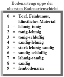
Soil class (attribute NKBT) [nr.]: The specification of the soil class is made via the ID assignment according to the definitions in the files for the global location parameters (see below). Unless own definitions are made, the encryption is based on the BK50.

Soil classes by BK50

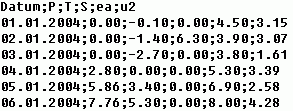
Climate data ID (attribute NKID) [nr.]: For the classification of climate data time series a climate data ID is assigned to the elements. The climate data ID is part of the file name that contains the associated climate data for the corresponding element. Example: Climate zone 1008  NKID = 1008
  file name = input_id1008.csv. Example of a file:

P = precipitation [mm/d]
T = Temperature [C°]
S = Sunshine duration [h/d]
ea = Vapor pressure [hPa]
u2 = Wind speed at 2 m height above ground level [m/s]
These time series must be provided by the user. All climate time series must begin with the same date and be dissolved in daily steps. The file directory is defined within the input menu.

Water content at field capacity (attribute NKFK): The water content at field capacity can, for example, be determined by the BK50. The unit of the attribute NKFK is [vol.-%].

Water content at permanent wilting point (attribute NKWP): The water content at permanent wilting point can, for example, be determined by the BK50. The unit of the attribute NKWP is [vol.-%].
