All attributes are element-wise and only applicable in horizontal or 3D models.
Attributes:
NMFN [-] (Meßer method),
NSFN [-] (Schroeder&Wyrwich method),
NUTZ [-] (Corresponds to NSFN, required for transient recharge calculation with soil water balance method),
NKFN [-] (RUBINFLUX method)
Depending on the method used to determine groundwater recharge, the elements are classified according to their land use. In the Meßer method, in addition to the subdivision into fields, forests, water areas and landfills. A distinction is made in particular for buildings according to the percentage of sealing. The Schroeder and Wyrwich method classifies according to fields, forests, buildings and water areas. The groundwater recharge estimation methods and the associated characteristic values are described in more detail in the chapter „How To – Calculation of the groundwater recharge rates“.
For example, large parts of the Ruhr area in Germany has detailed digital land use data available from the Ruhr Regional Association (RVR) as a so-called land use type catalogue map. This land use key can be converted into the land use codes (NSFN for Schroeder and Wyrwich, NMFN for Meßer) required by SPRING for groundwater recharge estimations. The RVR-Code must be provided via the element attribute KVRN for this purpose. When using standardised land use codes such as the CORINE land use and ATKIS, it is also possible to convert these into the land use classifications specified by Meßer for the NMFN attribute. The following figure provides an example of land use distribution in a model.
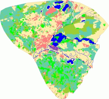
Example of land use distribution in a model
Stand: 06.05.2025 | 