Attributes: NMFN [-] (method of Meßer), NSFN [-] (method of Schroeder&Wyrwich), (horizontal and 3D models only), NUTZ [-] (according to NSFN, required for the transient recharge calculation considering the soil water balance), NKFN [-] (method of RUBINFLUX)
Depending on the procedure to calculate the groundwater recharge, the elements are clas-sified according to the specific land use. The method of Meßer divides into fields, forests, water areas and dumps and especially divides the building development after its percentage degree of sealing.
The method of Schroeder & Wyrwich classifies into field, forest types, building development and water areas.
Details of the calculation methods and their parameters are described in the chapter „How To – Calculation of the groundwater recharge“.
For large parts of the area exist detailed digital land use data from the Re-gionalverband Ruhr (RVR) as the so-called type of use catalog of the land use map.
This land use data key can be converted in the in SPRING required attributes NSFN (recharge calculation by Schroeder&Wyrwich) or NMFN (recharge calculation by Meßer).
For this the RVR-Code has to be provided by the element attribute KVRN.
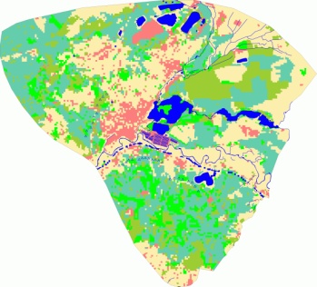
When using the standardized land use codes such as CORINE land use data and ATKIS data it is also possible to convert them in the divisions given by Meßer for the attribute NMFN. The following figure shows the distribution of land use in a model:

Distribution of land use in a model
